Updates
3/30/2021
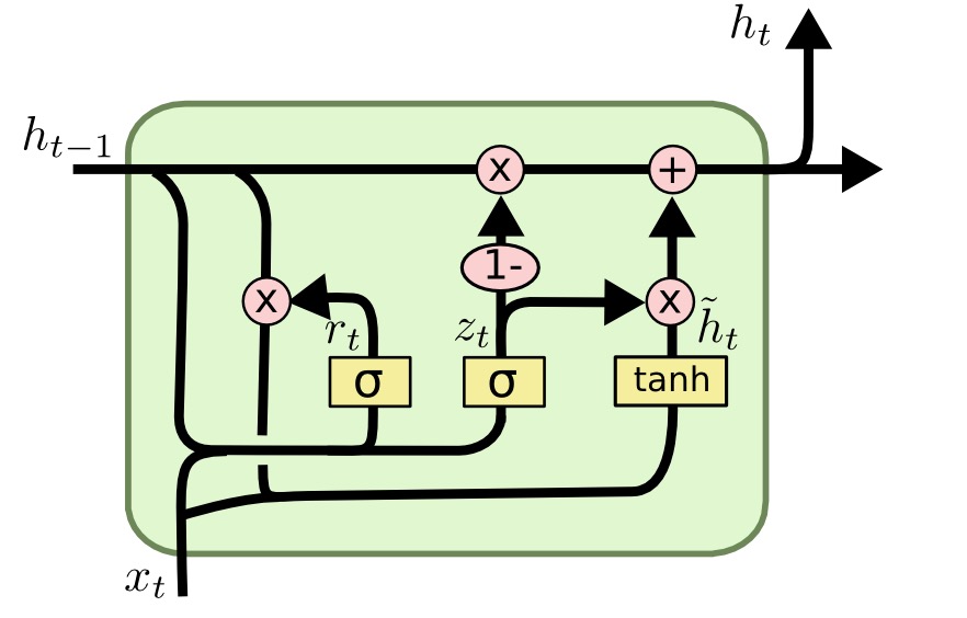
As part of my postdoc project, I have become very interested in different machine learning techniques for time series predictions and forecasting. The technique getting the most buzz right now in the hydrology world is called Long Short-Term Memory (LSTM for short). As far as I can tell this study by Kratzert et al was one of the papers that really kicked it off. Although the algorithm was initially developed for natural language processing (think speech recognition and translation), it has natural application to hydrology too. The reason is because, as the name suggests, it is able to store information from both long ago and more recent history to make predictions. This is helpful when for example, snow that fell several months ago is melting and contributing to streamflow today. Conceptually it makes a lot of sense, but it can be difficult to dive into the nitty gritty, especially if you’re a relative beginner like me. Here are some resources and blog posts that I have found particularly helpful:
- Blog posts that do a nice job of building LSTMs inuition off of recurrent neural networks:
- A nice example from cnvrg.io that works through the gates step by step and then goes through the implementation on pytorch.
- A nice application to streamflow forecasting: Feng et al. in Water Resources Research
1/31/2021
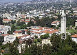
I feel really luck to start an incredible postdoc position this month. I’m working in Dr. Laurel Larsen’s lab at UC Berkeley in the Department of Geography. Her group conducts research across a broad range of topics from landslide iniaition proceses, to sediment particle dynamics, to watershed modeling. I will be working with long term datasets of flow and instream solutes to develop data driven models of watershed function and nutrient dynamics. I’m hoping to apply methods from machine learning and information theory to characterize and predict watershed behavior. I’ll be doing the postdoc remotely from Washington D.C., but it’s still cool to be a part of UC Berkeley.
9/28/2020
Jenny Pensky, Araceli Serrano, and others
8/30/2020
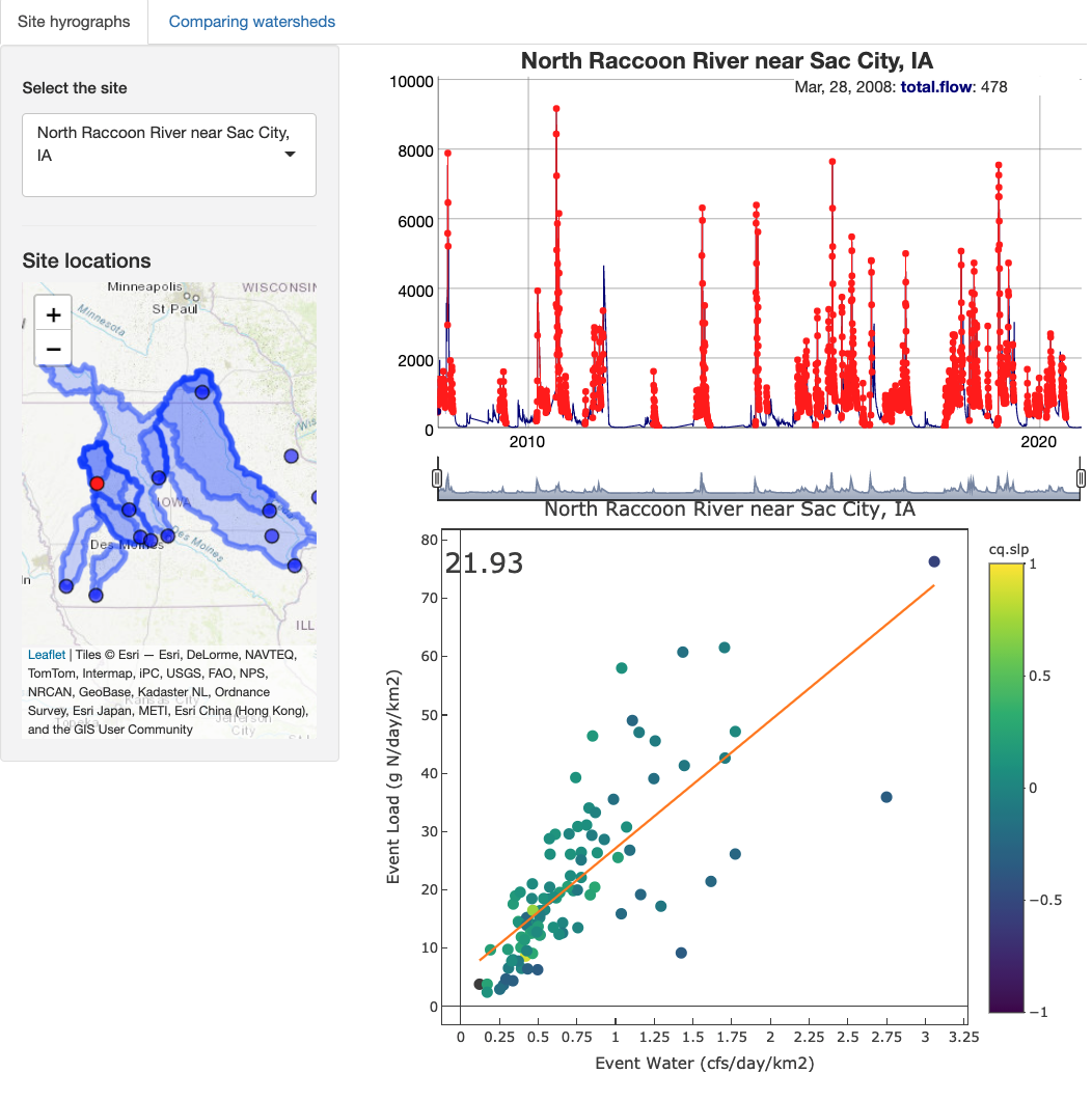
I have been working with Margaret Zimmer to use publicly available measurements of nitrate and discharge in agricultural watersheds to better understand how individual storm events can mobilize nutrients in streams and rivers. Initially, we focused our analysis on a few well-instrumented catchments in Iowa, but we want to expand our efforts to other watersheds with high-frequency nitrate measurements. To help us explore this data, I developed a data visualization app that downloads data from the USGS website, uses an algorithm to automatically select discharge events, and plots their cumulative nitrate loads color coded by their concentration-discharge slope. It also allows you to compare watersheds. It’s very much a work in progress, but it’s fun to play around with the data.
7/24/2020

PC: Alejandra Barrio-Gorski
As with so many things in 2020, my PhD defense was done over zoom from the comfort of our apartment in Santa Cruz (with a makeshift standup desk!). It was a bummer not to be able to celebrate with lab mates and friends from the department who made my time in Santa Cruz so special. At the same time, I feel lucky to be employed and healthy during a crazy hard time for so many people. I was able to celebrate with my family and spend some time at the beach.
06/20/2020
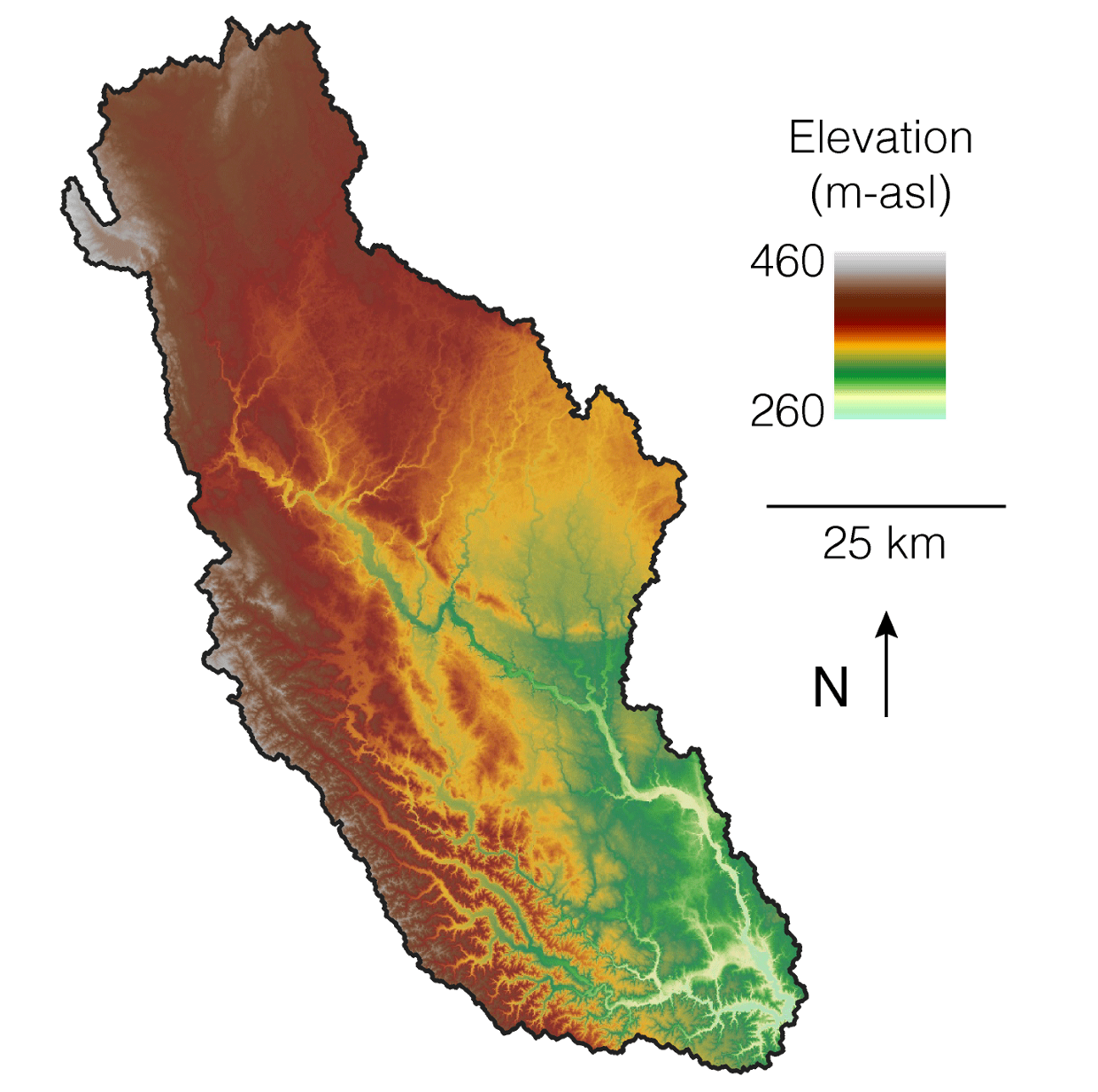
I have been working with a lot of spatial data lately, and with the quarentine I haven’t been able to access ArcGIS on my campus windows machine. This has forced me to learn how to work with spatial data in R and QGIS. I have found ways to do almost anything that I could do with ArcGIS, and all for free! Here is a markdown document with an example of a couple of the packages that I have found really useful. I use the elevatr package, which downloads digital elevation models (DEMs) for a region given points or a polygon (like the region to the right), and the mapview package, which is really useful for quickly and interactively viewing spatial data. Additionally, here is a list of resources that I have found particlarly useful in understanding and working with spatial data in R.
05/15/2020
I am super excited to join The Environmental System Dynamics Lab led by Dr. Laurel Larsen at UC Berkeley. I will be a post-doc, starting in January 2021, working on a project funded by a USGS Powell Grant in collaboration with the USGS and others. The project will focus on understanding key watershed storage parameters and transit time distributions across environmental, geologic, and anthropogenic gradients using a novel database of discharge time series and storage timescales.
04/14/2020
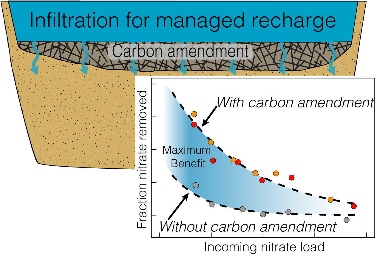
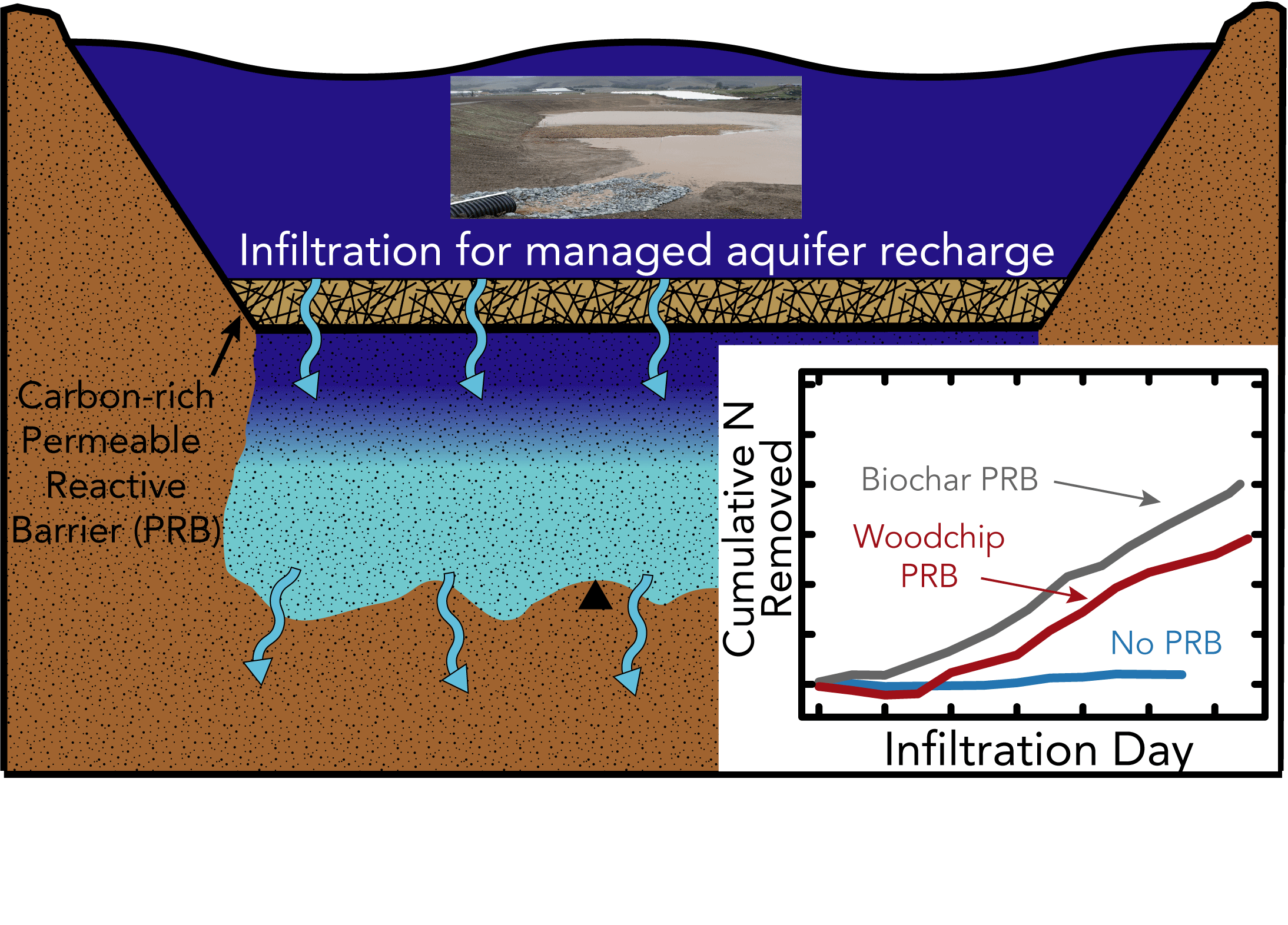
Check out our new paper that was just published in Science of the Total Environnment looking at the infiltration rate controls on denitrification during infiltration. We designed a way to collect intact sediment cores and pump artificial groundwater through them in the lab. Then we measured the changes in nitrate and carbon as water flowed through the soils at different rates. We also looked at the response from the soil microbial populations and it was a surpringly strong signal. Then, we added woodchips to see if that would jump start the denitrification process and it did! Results from this study and others like it are helping to develop technologies to improve groundwater quality through the use of managed aquifer recharge.
03/02/2020
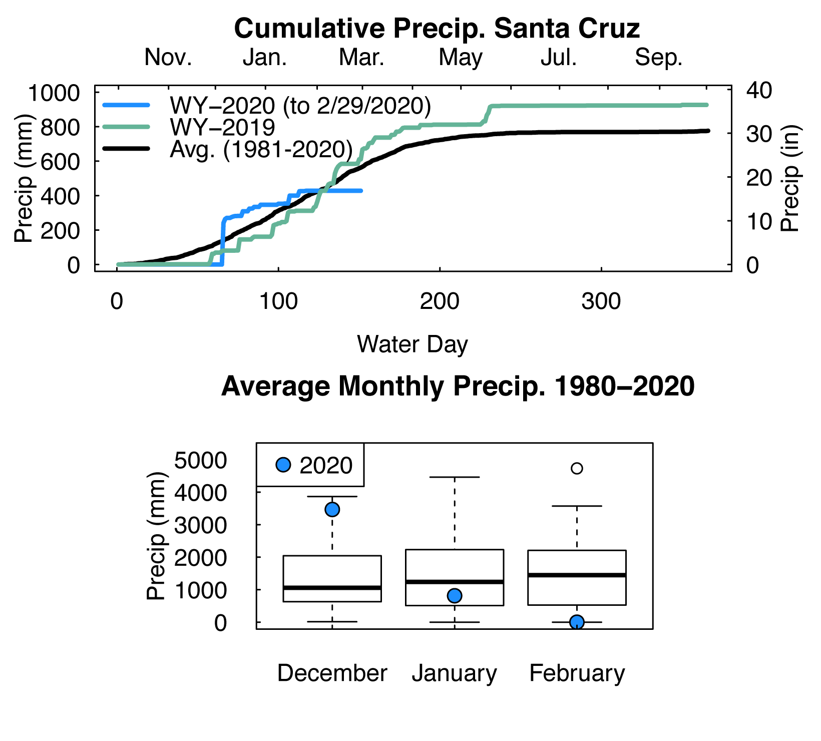
As of the end of February Santa Cruz has received 4,280 mm of precipitation in water year 2020, that’s just 75% of our average annual value up to that date. In Santa Cruz, January and February are generally our wettest months accounting for almost 40% of the annual rainfall on average. February was really dry (and beautiful), making it feel like it has been a particularly dry year overall, but I think this might just be a function of recency bias. January was a little below average for the area, and December was anomalously wet. In places like California, where extremes in precipitation are the expectation, it can be hard to gauge how far we’ve deviated from the norm without looking at the numbers. Global climate models can’t seem to agree on where we will see increases and decreases in overall precipiation with climate change, but there is concensus that intensity and variability of hydrologic extremes will continue to increase.
01/20/2020

As a part of the NSF-funded Graduate Research Internship Program (GRIP), I have been participating in an internship project that is a collaboration between the USGS, US-AID, and the governments of Lebanon and Jordan. The project aims to select sites for development of aquifer storage and recovery projects in an effort to increase water security in the region. As part of the project, I have developed a site suitability mapping application called MARMapS, that helps facilitate the creation of multi-factor suitability maps. I published it online at https://ggorski.shinyapps.io/marmaps/, check it out and play around with it. The code and user tutorials can be found on my github page.
12/10/2019

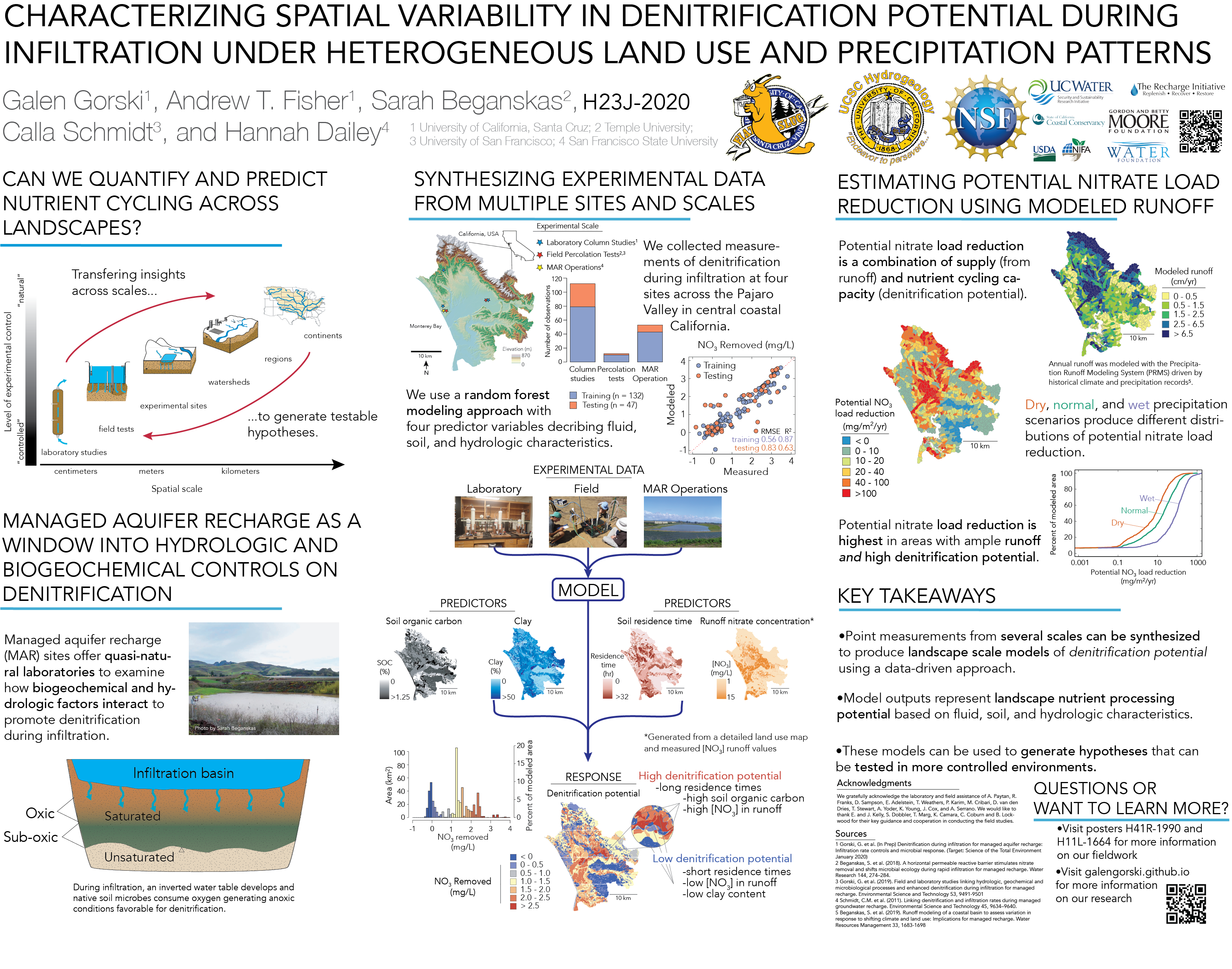
AGU was back in San Francisco this year, and I presented a poster based on the third chapter of my thesis entitled Characterizing spatial variability in denitrification potential during infiltration under heterogeneous landuse and precipitation patterns. See the poster here. There were also great posters from Jenny Pensky and Araceli Serrano that focused on changes in water quality during infiltration for managed recharge.
10/13/2019

Along with a team from the Hydrogeology group including Adam Price, Victor Bautista, Andrew Fisher and Jenny Pensky, I spent the day at a vineyard near Sacremento, CA. The vineyard is a site selected for one of the first flood managed aquifer recharge (F-MAR) projects in the region. During the rainy season about 1000 acres of the vineyard will be flooded with excess flows from the nearby Consumnes River in an effort to recharge the underlying aquifers. It’s the first project of its scale in the area, and if it’s succsessful, there are likley to be many more like it in the future. Led by Jenny (at the top of the ladder), we helped collect sediment cores that she will analyze and conduct experiments on to investigate changes in fluid geochemistry during infiltration.
09/12/2019

I submitted a proposal for the NSF post-doctoral scholarship. It’s a long shot but I think the project would be pretty cool. I proposed to work with Ben Bostick of Columbia University and Melinda Erickson of University of Minnesota to compare patterns and variability in arsenic contamination in Vietnam and Minnesota using some geophysical methods and a global dataset of groundwater arsenic concentrations.
08/24/2019
I just got back from a few weeks visiting Rachel Lauer and her lab group at the University of Calgary. I went up to see how they were using near-surface geophysical techniques in groundwater studies, and to try and learn some methods that could be useful to our work in California. Her lab has a bunch of really cool projects in some beautiful locations!
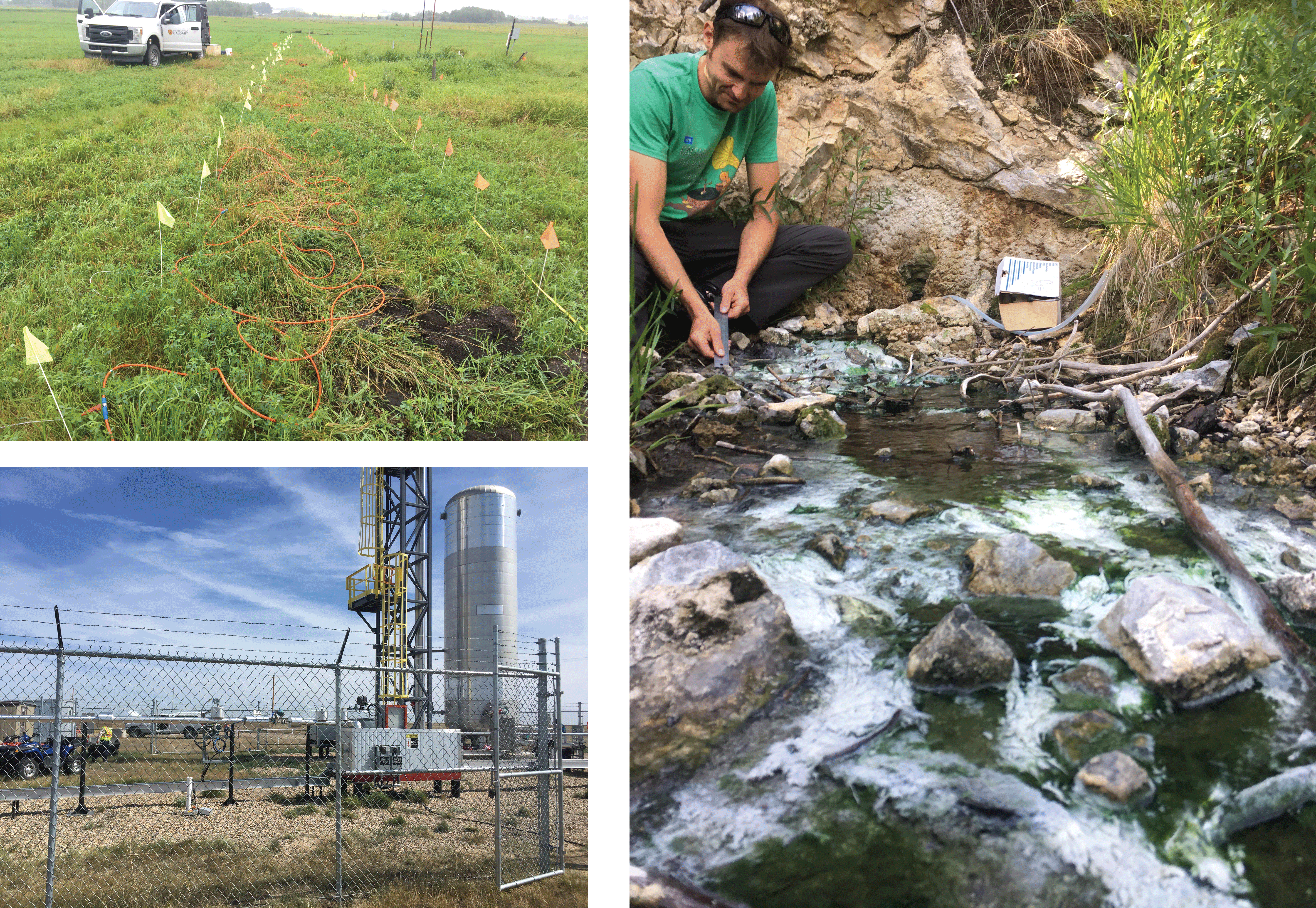
Upperleft: ERT lines collected to image soap hole plumbing. Lowerleft: CO2 injection site near Brooks, AB where U Calgary runs its geophysics field school. Right: PhD student Tom Wilson sampling geothermal water in Banff National Park. The white stuff is algea!
07/29/2019
Check out our new paper looking at denitrification during infiltration. Using a combination of field and lab studies we examine how flow rate and different soil amendments affect denitrification. This has implications for how managed aquifer recharge systems could be built and operated to improve water quality.
06/22/2019
With a team of grad students and professors, helped Andria Green construct boardwalks in Elkhorn Slough. She will be studying nitrogen cycling dynamics in various tidally influenced areas of slough.
06/13/2019
Finished TAing ESCI100, Intro to Environmental Systems, a calculus based modeling class looking at budgets and environmental processes. We only had four students, so they each got a lot of attention.
05/24/2019
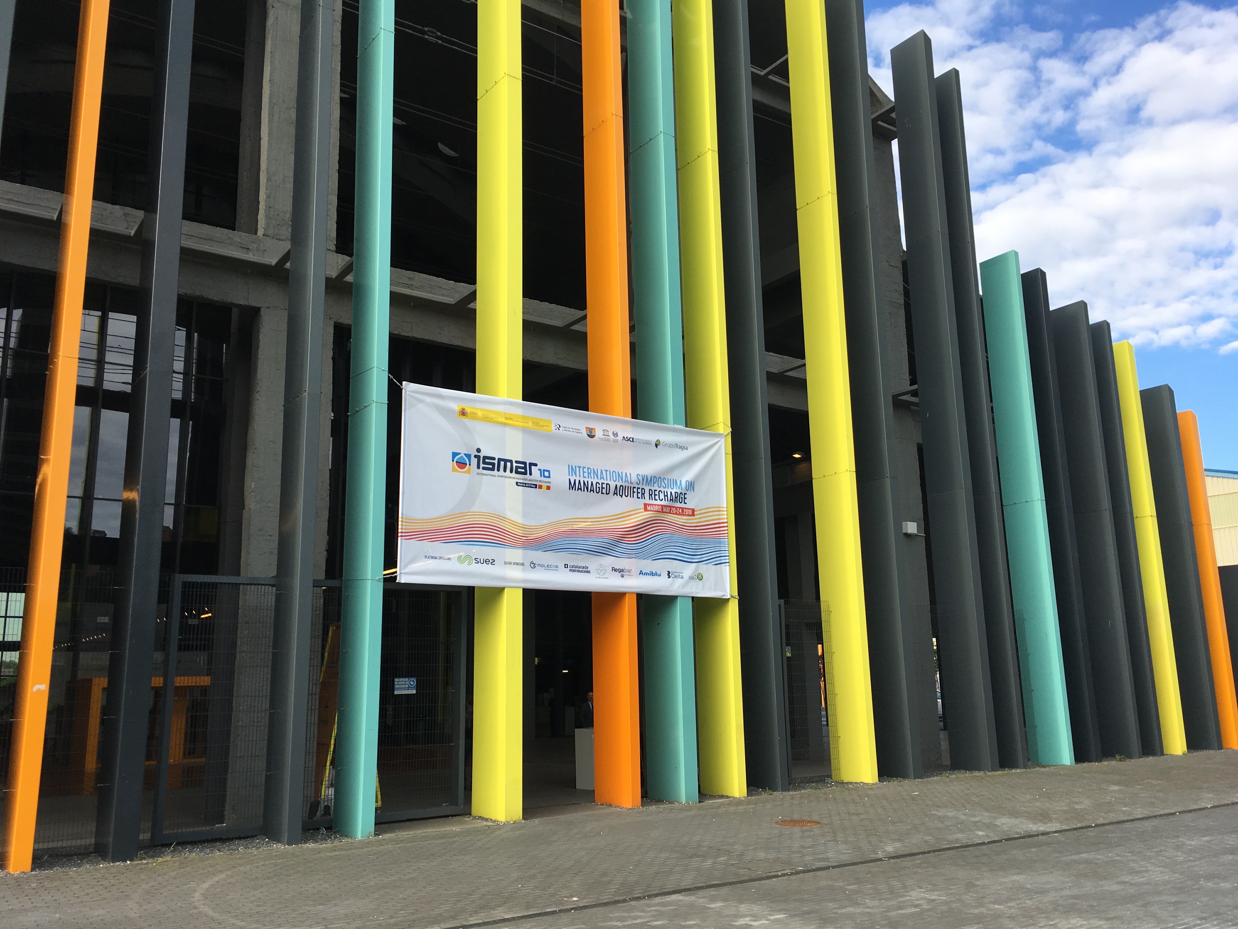
Gave two talks at the Internationl Symposium for Managed Aquifer Recharge in Madrid. One talk was focused mapping denitrification across landscapes (slides here) and the other talk was on the recharge suitability web application that I developed (slides here). The conference was very international, and it was exciting to see MAR projects from all over the world. It was also held in an old elevator factory!
02/05/2019
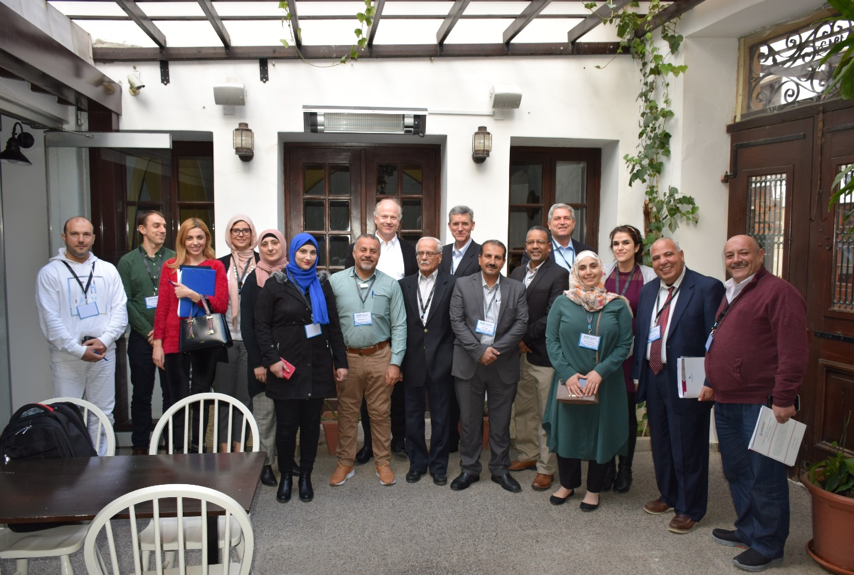
Attending a workshop in Nicosia, Cyprus with regional collaborators to help develop maps and modeling products for groundwater recharge suitability in the Middle East and North Africa. The workshop was part of a larger collaboration between US-AID, USGS, and the countries of Jordan, Lebanon, Palestine and other regional partners. Energizing to talk to folks from other parts of the world interested in similar topics!